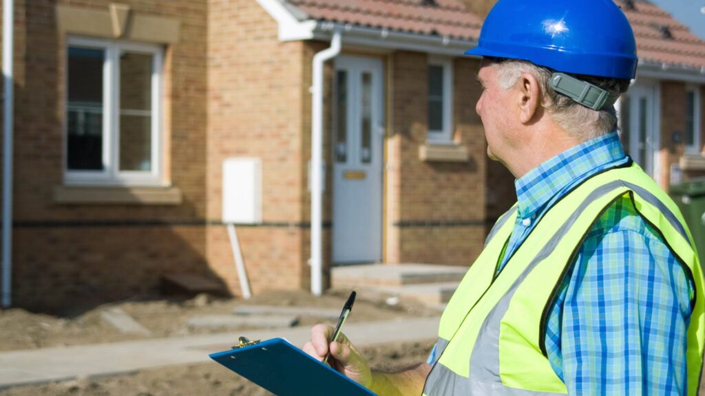
All construction projects require accurate and detailed data in order to be successful and safe for both workers and people who will use the final product. This data is often used to help teams make more informed decisions while also detecting any miscalculations that could lead to disaster when the construction project is underway. Any inaccurate or incomplete data will lead to costly delays and even hazards in the future if they aren’t corrected immediately.
This is where technology such as Light Detection and Ranging (LIDAR) comes in handy for measuring and recording data from construction sites that can be used to make informed decisions and accurate plans.
Applications like the RENDR app take advantage of LiDAR to allow contractors to take 99.6% accurate measurements of spaces in seconds. Simply scan the space you wish to take measurements of and let the RENDR app do the rest of the work.
From there you can upload 2d and 3d floor plans into which ever modeling software you use.
Stop wasting time taking measurements by hand, download the RENDR app today and see the power of LiDAR today!
Overview of LIDAR in Construction
LIDAR uses lasers to accurately measure distances between spaces while simultaneously recording enough data to create 3D models of entire environments. In construction, this is generally used for mapping out an entire construction site, and capturing important data such as elevations, angles, and distances. This enables construction teams to create incredibly accurate models of their sites, thus giving them more power in planning and decision-making.
Much of the data recorded with LIDAR will be used for site planning, construction design, and also monitoring. The data is often used when identifying potential construction challenges, and it can also encourage rapid progress by speeding up timelines and lowering project costs. It can also give workers the peace of mind knowing there are accurate measurements in their construction work that will reduce the potential of hazards. LIDAR data can also be used to identify potential dangers on a construction site.
Advantages of Using LIDAR for Construction
There are a number of advantages to expect when using LIDAR for construction. The most common use would be to capture detailed and accurate data about a construction site or building that can then be used to create 3D models and point clouds. That data can then be analyzed to ensure accurate measurements, or it can be used for design purposes.
This improved visualization offers endless planning opportunities, and it can drastically improve the speed at which a project is completed while also reducing operating costs. LIDAR technology is simple to set up and doesn’t require a huge budget, making it a cost-effective option for construction projects.
Applications of LIDAR in Construction
The most common applications of LIDAR in construction include:
- Site planning and design
- Building inspections and assessments
- Quality control and progress monitoring
LIDAR is a fast system that can produce accurate data much more quickly than traditional construction site scanning systems, making it excellent for site planning and design. The accurate data can also be used to perform site-wide inspections to prevent potential hazards.
Steps for Using RENDR’s LiDAR in Construction
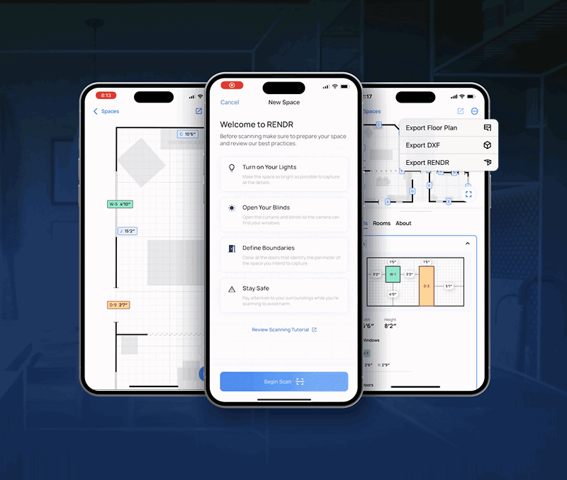
To properly construct the interior space, the first step is to utilize the Rendr app to scan the area. Before beginning, it is essential to ensure the room is clean and orderly and complies with the software’s guidelines. If there is uncertainty about the scanning process, the tutorial included in the app can be viewed beforehand.
To initiate the scan, aim the camera at one of the room’s corners and wait for the “lightlines” to appear. Then, gradually move your device around the room, capturing every surface.
By following these procedures, you can create a 3D model of the space. The Rendr app captures all of the necessary dimensions, eliminating the need for manual measurement.
Once the scan is complete, you can upload it to the Rendr platform in various formats that meet your organization’s requirements. Select the “accept and save” or “redo” option after completing the scan.
The subsequent stage involves converting the 3D model into a schematic floor plan, utilizing the information obtained from the scan. This process provides comprehensive data about each wall’s dimensions, allowing for a detailed view of the space.
Lastly, you can customize the schematic floor plan to meet your specifications. Add or modify project notes, redraw dimensions, or include new features. With just a click, several team members can access detailed information about the area.
Best Practices for Using LIDAR in Construction
It’s important that the equipment you use is properly calibrated and maintained. Run several tests and compare the results with real-world measurements to ensure that they are accurate. If you have existing data that has been verified, it’s a good idea to cross-check this with your LIDAR data to ensure accuracy. It’s also a good practice to use multiple scanning positions and then collect the data for comparison and averaging. This will provide a much more accurate set of data than if you only scanned from a single position.
You should also train operators in the use of LIDAR equipment and software. This will ensure the system is maintained, produces accurate results, and the raw LIDAR data can be used effectively. Lastly, it’s also a good idea to use proper data storage practices, such as backing it up, to prevent potential data loss.
Try The RENDR App Free Today!
Are you tired of manual measurements and drawings in construction projects? Want to experience a more efficient and accurate way of scanning and creating 3D models of interior spaces? Then, it’s time to try the RENDR app!
With the power of lidar technology, the RENDR app can scan and generate a 3D model of any interior space in just a few minutes. This app eliminates the need for manual measurements and drawings, making the construction process quicker, more efficient, and more accurate.
So, what are you waiting for? Download the RENDR app today and see for yourself how lidar technology can transform your construction capabilities. With just a few clicks, you can create detailed 3D models of interior spaces and enhance your construction projects like never before. Don’t miss out on this opportunity to revolutionize your construction capabilities – try the RENDR app today!
All construction projects require accurate and detailed data in order to be successful and safe for both workers and people who will use the final product. This data is often used to help teams make more informed decisions while also detecting any miscalculations that could lead to disaster when the construction project is underway. Any inaccurate or incomplete data will lead to costly delays and even hazards in the future if they aren’t corrected immediately.
This is where technology such as Light Detection and Ranging (LiDAR) comes in handy for measuring and recording data from construction sites that can be used to make informed decisions and accurate plans.
Applications like the RENDR app take advantage of LiDAR to allow contractors to take 99.6% accurate measurements of spaces in seconds. Simply scan the space you wish to take measurements of and let the RENDR app do the rest of the work.
From there you can upload 2d and 3d floor plans into which ever modeling software you use.
Stop wasting time taking measurements by hand, download the RENDR app today and see the power of LiDAR today!
Overview of LIDAR in Construction
LiDAR uses lasers to accurately measure distances between spaces while simultaneously recording enough data to create 3D models of entire environments. In construction, this is generally used for mapping out an entire construction site, and capturing important data such as elevations, angles, and distances. This enables construction teams to create incredibly accurate models of their sites, thus giving them more power in planning and decision-making.
Much of the data recorded with LiDAR will be used for site planning, construction design, and also monitoring. The data is often used when identifying potential construction challenges, and it can also encourage rapid progress by speeding up timelines and lowering project costs. It can also give workers the peace of mind knowing there are accurate measurements in their construction work that will reduce the potential of hazards. LiDAR data can also be used to identify potential dangers on a construction site.
Advantages of Using LiDAR for Construction
There are a number of advantages to expect when using Li the new banner DAR for construction. The most common use would be to capture detailed and accurate data about a construction site or building that can then be used to create 3D models and point clouds. That data can then be analyzed to ensure accurate measurements, or it can be used for design purposes.
This improved visualization offers endless planning opportunities, and it can drastically improve the speed at which a project is completed while also reducing operating costs. LiDAR technology is simple to set up and doesn’t require a huge budget, making it a cost-effective option for construction projects.
Applications of LiDAR in Construction
The most common applications of LiDAR in construction include:
- Site planning and design
- Building inspections and assessments
- Quality control and progress monitoring
LiDAR is a fast system that can produce accurate data much more quickly than traditional construction site scanning systems, making it excellent for site planning and design. The accurate data can also be used to perform site-wide inspections to prevent potential hazards.
Steps for Using RENDR’s LiDAR in Construction
To properly construct the interior space, the first step is to utilize the RENDR app to scan the area. Before beginning, it is essential to ensure the room is clean and orderly and complies with the software’s guidelines. If there is uncertainty about the scanning process, the tutorial included in the app can be viewed beforehand.
To initiate the scan, aim the camera at one of the room’s corners and wait for the “lightlines” to appear. Then, gradually move your device around the room, capturing every surface.
By following these procedures, you can create a 3D model of the space. The RENDR app captures all of the necessary dimensions, eliminating the need for manual measurement.
Once the scan is complete, you can upload it to the RENDR platform in various formats that meet your organization’s requirements. Select the “accept and save” or “redo” option after completing the scan.
The subsequent stage involves converting the 3D model into a schematic floor plan, utilizing the information obtained from the scan. This process provides comprehensive data about each wall’s dimensions, allowing for a detailed view of the space.
Lastly, you can customize the schematic floor plan to meet your specifications. Add or modify project notes, redraw dimensions, or include new features. With just a click, several team members can access detailed information about the area.
Best Practices for Using LiDAR in Construction
It’s important that the equipment you use is properly calibrated and maintained. Run several tests and compare the results with real-world measurements to ensure that they are accurate. If you have existing data that has been verified, it’s a good idea to cross-check this with your LiDAR data to ensure accuracy. It’s also a good practice to use multiple scanning positions and then collect the data for comparison and averaging. This will provide a much more accurate set of data than if you only scanned from a single position.
You should also train operators in the use of LiDAR equipment and software. This will ensure the system is maintained, produces accurate results, and the raw LiDAR data can be used effectively. Lastly, it’s also a good idea to use proper data storage practices, such as backing it up, to prevent potential data loss.
Try The RENDR App Free Today!
Are you tired of manual measurements and drawings in construction projects? Want to experience a more efficient and accurate way of scanning and creating 3D models of interior spaces? Then, it’s time to try the RENDR app!
With the power of lidar technology, the RENDR app can scan and generate a 3D model of any interior space in just a few minutes. This app eliminates the need for manual measurements and drawings, making the construction process quicker, more efficient, and more accurate.
So, what are you waiting for? Download the RENDR app today and see for yourself how lidar technology can transform your construction capabilities. With just a few clicks, you can create detailed 3D models of interior spaces and enhance your construction projects like never before. Don’t miss out on this opportunity to revolutionize your construction capabilities – try the RENDR app today!